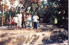
Traveling
through the Clouds of the Andes
New
York (July 2014)
From the Journal of the Bengal Engineering College Alumni Association of U.S.A. and Canada 2014
When rest of the world
was heading to South America to join the World Cup Shefali and I thought of
heading to South America too but on a westward path. Our journey took us
through some of the most fascinating areas of the world over the Andes Mountain
Range and along the Pacific Ocean further west, not the Atlantic Ocean in the
east that World Cup host Brazil shares. Andes is the longest mountain range of
the world stretching for about 4,500 miles (7,250 kilometers) from Columbia,
Venezuela in the north through Ecuador, Peru, and Bolivia in the center,
finally ending in Chile and Argentina in the south. Except Himalayas, Andes have
some of the tallest peaks of the world. This journey took us through Peru,
Bolivia, Chile and Easter Island or Isla de Pascua. We visited some other Andean
nations in our earlier trips. Shefali visited Peru too a few years ago, the home
of the Inca peoples.

South
America
We first went to Lima,
the capital city since the days of the Spanish Conquistadors’ colonization of
the New World. Lima is a modern, bustling city by the Pacific Ocean. The city
is home to some of the best examples of Spanish colonial architecture with huge
plazas, public buildings and parks, now laced with tall modern office and
apartment buildings, and a few pre-Columbian sites. For a long time Spain ruled
the entire continent from Peru. Spain went there to take Peru’s enormous supply
of gold and silver home. Many of the ancient Inca gold and silver jewelries
look much like old Indian jewelries and puja artifacts at Hindu-Jain-Buddhist
temples. As many of the Peruvians – and South Americans – look like us we had a
certain advantage as long as we didn’t open our mouth, as well as some
disadvantage, especially for the lack of knowledge of Spanish. Nevertheless, in
all these nations people were very friendly when they knew we were from the
United States, even more inquisitive when they knew we were Indians – de la
India – especially Hindu. Locals frequently asked us “Are you Hindu?” first instead
of “Are you Indian?” Many of our Lima friends
told us to visit the prestigious Miraflores neighborhood by the sea with tree-lined
bungalows, diplomatic missions and million-dollar homes – which we did, and the
adjacent Bohemian Barranco area. Although Lima is by the Ocean, yet the city
sits on hundreds of feet high cliff, like a wall, from the beach. This is the
first city we traveled to where the Metro mass transit is at the street level
run by buses, not on rails. Buses with generally two coaches run on dedicated
lanes.

(US
President John F) Kennedy Park in Downtown Lima

Lima
Lima
Machu
Pichu, Inca Religion, Culture and Country:
The Peru we were
interested in came alive when we reached Cuzco (also Cusco) at 8,000 feet high
in the Andes Mountain, in the heart of Inca – not Spanish – country. From the
First Millennium to the middle of 15th Century Incas built one of
the most impressive civilizations of the world, until destroyed by the Spanish
Conquistadors and their fellow Missionaries. Cusco was one-time capital of the Inca
Empire which covered several of our present-day nations, and is the gateway to
the famous Inca city of Machu Puchu, high in the mountains, 100 kilometers
away. Yet Machu Pichu – also a one-time Inca capital – was never discovered by
the Spanish Conquistadors in 400 years until 100 years ago in 1909 by Yale
professor Hiram Bingham.
Today journey to Machu
Pichu is lot simpler, yet needs strength and energy. It is one of the most
visited sites in the entire continent. Number of visitors is strictly
controlled by the Peruvian Park authorities with a maximum of 2,500 visitors allowed
each day. Most visitors take a glass-domed narrow-gauge luxury train from Poroy
Station of Cusco to Aguas Calientes on the foothills of the mountain; from
there one must take a 20-minute Peruvian National Park bus which climbs at
least a kilometer to the entrance of Machu Pichu ruins, then there is another
kilometer or two of climb up and down throughout the spectacular site. The
train ride itself is one of the most remarkable rides of the world through
narrow valleys, rain forest, riverbanks, gorges and tunnels, making only two
stops at Ollantaytambo and Urubamba.

At
Machu Pichu with the Sacred Mountain on the Back


Peruvian Inca Temple
Machu Pichu was a well-planned
city on top of a mountain range. What baffles everyone how the Incas were able
to build on top of steep mountains with no easy path of transporting men and
material? Inca religion is very much like Hinduism with reverence to Mother Nature,
sun, moon, earth, sacred mountains, animals, plants, and rivers playing
important roles. In the planned city the emperor’s quarter faced the Sacred
Mountain on the east, as does many Hindu temples. The city had temples to
sacred animals of llama, condor and snake – just as temples to many sacred
animals, birds and snakes are found in Hindu lands. Much like Hinduism revered
deities represented many of those sacred forms, until Conquistadors and
missionaries banned the practice of Inca religion, Inca languages and offering
prayers at temples. Many of the 15th and 16th Century gorgeous
gold-decorated Catholic churches sit on top of sacred Inca temples. Catholic
missionaries often used the foundation and roof of the old Inca temples to
construct new churches just as the Islamic conquerors had built Islamic mosques
on top of indigenous religious temples in Arabia, the Middle East, India and
elsewhere. The city of Machu Pichu was built with huge stone blocks. They also
curved out jhoom-like agricultural
terraces on the side of steep hills for producing food for the residents. But
to build terraces they had to transport huge stones to create flat storied
terraces, often hundreds of feet in height, which then were filled up with
stone chips, dirt and soil for growing crops. These agricultural terraces are
found throughout the region. The city of Machu Pichu had places of governance,
residences of nobles and commoners, schools, granaries, storage, working areas,
temples to deities, walkways, guard house, astronomical observatory and so much
more. To enjoy the ruins one must be prepared to walk up and down mountain
paths connecting different sections. One must also be prepared for rain, fog
and cloud. In one moment it may be sunny, the very next it could be raining, or
fog/cloud can move in at that 8,000 through 10,000 feet altitude. For very
hardy travelers one can take even long trails of several kilometers to the next
mountaintop or to another Inca ruins needing overnight stay and special
permission. One can also take 3-day 40 kilometer trek to the ruins from
Urubamba that Shefali and our daughter Joyeeta took few years back. One is able
to cover Machu Pichu in 2 to 3 hours either with or without a guide, or can
spend a day or two very easily. Walking through the ancient city we often
stopped on our path with awe just wondering how the Incas were able to
transport those hundred-ton stone slabs, columns, roofs and walls up the steep
hills without any road, crane, lift, truck or helicopter. Moreover aligning
them together in a close fit is equally awesome. Accomplishing those
engineering and architectural marvels still leave many questions unanswered.
Machu Pichu was built in the 1400s, and abandoned in the 1500 after Spanish
invasion. In honor of native peoples Peru’s first indigenous President Dr. Alejandro
Toledo, a Quechua, held his 2001 presidential inauguration at Machu Pichu, taking
all the guests to the ancient site, combining both Inca and Catholic religious
practices. There are other wonderful Inca sites in Peru. On route from Cusco to
Puno, close to Lake Titicaca (Titikaka), I liked the planned Inca city of
Raqchi, which now lies in ruins in the middle of a beautiful bountiful valley
surrounded by snow-capped mountains. Growing crops at such an altitude is
difficult.
During our trip, seeing
“Hindu tourists” in us, we were surprised to learn that some Peruvians have
taken to Hinduism, first introduced by ISKCON. Thus in Lima, Cusco or Puno in
Peru, or La Paz or Copacabana in Bolivia, or Santiago in Chile one can easily
find such vegetarian restaurants like Gopal, Govinda Lila, Krishna, Vrindavan,
Radha’s and Dharma. In Lima at a restaurant filled with locals at lunch the
owner of the eatery volunteered as we were paying our bill, “my native Peruvian
neighbor is Hindu.” Many local Hindu families host travelers as Joyeeta and
Shefali stayed with such a family in their last trip. All types of food are
plentiful, including American burgers, but we mostly tried local dishes,
including street food. Incas gave the world potato, chili, tomato and maize
thus one can have varieties of potatoes, corns and chilies, as well as llama
meat. It seems every dish is served with a giant portion of potato fries. Our
road journey practically started at Machu Pichu from there we covered about
3,500 kilometers by road and rail, through 3 nations, reaching over 17,000 feet
and hugging spectacular glaciers, mountains, valleys, rivers, lakes, ornate
cathedrals, native villages, towns and Pacific Ocean. After about 2,000
kilometers in the Andes, we reached sea level in the northern Chilean city of
Antofagasta. In southeast Peru we came close to the origin of 700
kilometer-long fast-flowing Urubamba River, which joins Ucayali River, which
further down joins the mighty Amazon for 6,300 kilometers journey to the ocean.
The entire journey by bus and train was feast for the eyes and food for the
mind. Throughout the trip we came across mostly backpackers from South and
North America, and Europe in their 20s and 30s, but neither any Indian nor
Bengali. There were many young Chinese travelers though, including young
Wangxing, our fellow traveler at Easter Island. Unlike young backpackers, we
carried two small carry-ons for our long journey. Throughout the region very
few spoke English, yet American music blared everywhere. In many places there
are bilingual signs. In downtown La Paz there were a few shops with Spanish and
Hebrew signs.
Lake
Titicaca:

Welcome
to Island in Titicaca; a MayurPankhi Reed-boat on the Blue Lake in the
Background
 Puno Cathedral
Lake Titicaca is one of
the natural wonders of the world shared by Peru and Bolivia. It is the world’s
highest navigable lake. The lake region is inhabited by Aymara peoples. Clear
blue lake is also famous for having “floating islands.” On Titicaca grows a
type of reed that Aymaras pack tightly up to several feet thick to create
islands where people live, lot like Manipur’s Loktak Lake floating islands. The
reeds are so light that it floats even when packed tightly. Aymaras use those reeds
to build their huts as well as boats. In central islands there are primary schools,
small shops and restaurants. There are eco-toilets that do not pollute the
lake. Beyond primary schooling, one has to go to nearby cities on shore for
high school, college, banking, and for medical care, lot like deltaic Bengal.
Teaching Aymara was banned until very recently when both Peru and Bolivia
elected presidents from indigenous communities. Yet, I was told by Aymara and
Quechua parents that the languages are taught only at primary level. There are
still areas in these isolated islands, in distant highlands, forests and remote
villages that Aymara, Quechua or other non-Spanish languages are spoken as
first language.

Reed-built
Island (seen on the Foreground) on Titicaca, with Fellow Travelers


Copacabana Cathedral
The Flower Sellers of Copacabana, Bolivia
Bolivia,
the Andes Mountain, Abaroa Reserve and Salt Flat:

Bolivia is a huge resource-rich
nation with 10 million people, making it one of the low-density nations. (Bolivia
is almost 9 times larger than Bangladesh, yet she has 1/16th her
population.) On our trip we traveled for thousands of kilometers through the
Andes Mountain plateau, called Altiplano, reaching a high of 17,000 feet. We
bypassed Bolivia’s vast agricultural plains in the east. From the city of
Copacabana on Lake Titicaca we headed south to the capital city of La Paz,
world’s highest capital at 12,000 feet, and four hours by express bus. The city
is like a bowl lies in a valley surrounded by snow-capped mountains, tree-less,
covered with brick-facing buildings. La Paz is above tree line. It looks great
during the day, but she looks even nicer at night with glittering lights in
dark as far as eye can see. La Paz is comparable to Dhaka in its massive
traffic jams, and in another respect – with vendors on every inch of sidewalks
and medians – looks like Kolkata. The city has many Spanish-era buildings, but
now dwarfed by tall modern buildings. Even with its huge traffic and crowded
streets La Paz seemed to be relatively relaxed as women and men walked the
streets, ate at restaurants, and shopped at malls till late in the evening. It
seemed to us that women’s participation at work is possibly higher than the
U.S., India or Bangladesh. There were women as police, banker, bus driver,
conductor, laborer, guide, vendor and more. Of the three countries we visited
visibility of women in public sphere was highest in Peru, no doubt.

Bolivian
Train, run by an Andean Multinational Company

Park at Oruro City Center
From La Paz we headed farther
south for the famous Salar de Uyuni, or Uyuni Salt Flat. To reach Uyuni, a
350-kilometer bus ride took us to Oruro, then from there to Uyuni by a
350-kilometer train ride in one of the “best train rides of the world,”
according to many travelers. This train runs only twice-a-week. After Uyuni junction
one day the train heads to Argentina and the other day it heads to Chile. For
travelers connecting to this train from Oruro is extremely important. The track
was laid by the British to take ore to a Chilean port. In 1800s and 1900s Uyuni
was a bustling city when price of tin was high and world’s main supplier was
Bolivia. Since mid-1980s when tin prices fell to the bottom, and mines closed,
Uyuni had to reinvent herself as a tourist mecca servicing tourists who come to
visit the Salt Flat and the Eduardo Abaroa Andean Fauna National Reserve
(Reserva Nacional de Fauna Andina Eduardo Abaroa), the natural wonders of Altiplano.
Our hotel at Uyuni was built by a British in the late 1800s like an old bonedi Calcutta mansion with a central courtyard.
Abaroa and Salt Flat together form the southwest corner of Bolivia bordering
Chile and Argentina. On a daily basis, starting at breakfast, hundreds of
4-wheel drives take visitors to Salt Flat and to the Reserve for 1-day to 3-day
trips. In our case we chose to head to Chile at the end of the trip.

Uyuni Village Center

In
Uyuni Salt Lake
The Uyuni Lake is about
11,000 sq. kilometers, covered with salt that is over 100 feet thick, feels
more like marble stone. It is so flat that many race car drivers try out their
cars at hundreds of kilometers of speed. It is truly an unworldly site, and
appears like polished marble. There are craftsmen who make large statues made
out of salt blocks, and many homes – and our hotel bordering the flat – are built
with salt bricks. This area holds the record of highest daily fluctuation of
temperature in 24 hours. It can vary from over 100 F in the day to minus 40 F
at night. This region borders on the west the Atacama Desert, the driest desert
of the world, stuck between Pacific Ocean and southwest Bolivia. A journey of 3
days and two nights took us through one of the most scenic areas we have ever
been, with show-capped mountains of various colors, glaciers, lakes, desert,
“stone trees,” geysers, streams, wild llamas, alpacas, foxes, vicunas, flamingoes,
water birds, dirt and salt roads through nowhere. Generally 4-wheel jeeps take groups
of six tourists on a trip which also provide meals and lodging. Jeeps also carry
complete supply of food, water and gasoline for the entire trip.

Our
Tour Group at Laguna Verde: A Couple from France and a Single from South
Carolina
Jeep would stop at
places of natural wonder like Laguna (lagoon) Colorado, volcanos, Laguna
Canapa, Arbol de Piedra (Stone Tree), Stone Island of Salt Lake (looks more
like stone outcrop from a marble floor), hot spring for bathing and more. Parts
of the region looks like high-altitude desert.

At
Stone Tree

Sculpture made out of Salt Bricks

As we traveled from end
of May through early June, it was southern hemisphere’s late fall. Nights at
Abaroa Reserve were quite cold needing sleeping bag and several blankets as temperature
dropped well below freezing. (There was no heat at lodges within the Reserve.)
Yet at daytime a coat and a hat were enough to get by, but many youngsters wore
only t-shirts.
Chile:
At the end of the 3-day
journey through Altiplano we entered Chile in the middle of nowhere at the
southeast part of Atacama Desert. As predicted by our fellow travelers, Chile
seemed to have a high standard of living, and its infrastructure to be at par
with North America and Europe. In Chile we covered over 1,700 kilometers by
road from Atacama in the north all the way south to Santiago. We had a pot-hole
free ride that made our journey quite pleasurable. All the long-distance buses are
of high quality with sleeping, semi-sleeping, and sitting arrangements, with toilets,
and most frequently serving drink and snack. (This is true for Bolivia and Peru
as well.) Chile is a very long “string bean” country; 4,300 kilometers long.
Thus the north-south national highway acts like a spine that holds the nation
together. Throughout its entire length on the east one can see the Andes
Mountain Range and the Pacific Ocean on the west.

Museum at San Pedro de Atacama, Chile
Santiago is a very
modern city with Spanish-Italian architecture; and now of course many modern buildings
as in New York. The city has a large subway network, a great bus network and train
lines to suburbia. Chileans pride themselves of their city with very little
crime. For us it seemed to be true. This is first city in six continents where
the taxi drivers refused to take extra money when they missed our hotel and had
to make a detour. They would ask less money than their metered taxi would read.
Santiago has also created many pedestrian plazas throughout the city, and is
full of sidewalk cafes. Its street flavor is more European than Latin American.

Santiago
Easter
Island:
On the last leg of our journey we headed to Easter Island
or Rapa Nui in Polynesian and Isla de Pascua in Spanish. This tiny island of 63
sq. mile is in the middle of Pacific Ocean requiring a 5 to 6 hour jet flight
from the nearest South American continent, 3,500 kilometers away. According to
Wikipedia, it “is one of the most remote inhabited islands in the world. The
nearest inhabited land (50 residents) is Pitcairn Island 2,075 kilometers
(1,289 mi) away, the nearest town with a population over 500 is Rikitea on
island Mangareva 2,606 km (1,619 mi)
away, and the nearest continental point lies in central Chile, 3,512 kilometers
(2,182 mi) away.” This is still a
Polynesian-majority island, but mostly speaking Spanish. Easter Island is
famous for her stone sculptures or moias built by the first residents, the
Polynesians.

Moias at Tangariki during routine Rain Shower
This
is possibly one of the very few places on earth where one can walk to
“downtown” of the capital, Hanga Roa, from the airport. Practically all the 5,000-plus
residents live in Hanga Roa, heavily depended on tourism. To visit the moais
one must either rent a car or join a tour. All the sites can easily be covered
in one day, although two days are optimum. As in Machu Pichu in Peru, rain
gives routine, unexpected company. So having a poncho handy is a must. Early
Polynesians must have been strong and powerful as they curved out these large statues
and moved huge stones over long distances.
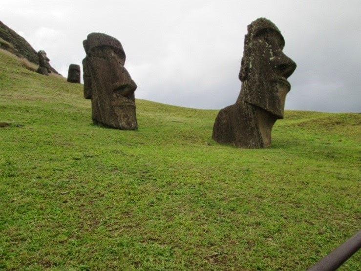
Moias at the northern National Park

As
everything has to be imported by air from mainland Chile, cost of living is
quite high in Easter Island. (In general, from Peru to Easter Island,
American-style hotels are quite costly, probably costlier than in the U.S., in
spite of lower per capita income.) The island has many tropical plants. Our
hotel was full of guava trees, yet no one picked those fruits, and one can have
it for picking. Fish is one of the few resources that are harvested locally. For
fish lovers, there are many seafood dishes that are a combination of Polynesian
and Spanish traditions. On our return journey, we spent extra days in Santiago,
Chile – as it is the gateway to Easter Island – before heading home to New
York.